
Weather apps and reports for stormy days
July has arrived and with it the first month of the official Hurricane Season is over. Four more months remain. July was storm-free throughout the Caribbean, but very annoyingly gusty. Only the American and Mexican coasts have seen a bit more of action.
The website of the NHC (National Hurricane Center, USA) of the NOAA (National Ocean and Atmospheric Administration) is the first thing sailors in the Caribbean look at in the morning and the last thing at night. On their website www.nhc.noaa.gov all forecasts and probabilities can be seen. And in addition, all people with floating beds study all possible weather apps several times a day.
Elsa is coming
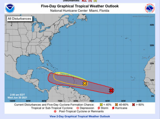
Today the NHC has named “Elsa”, i.e. the 5th letter is given to the fifth storm of the season. Naming storms allows for quicker identification, as it is not uncommon to have several storms in a region at the same time. The names of devastating storms like Irma or Maria are no longer used and virtually end up in the inglorious Hall-of-Fame.
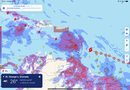
As I write this, “Elsa” has entered the Caribbean from Africa across the Atlantic, at the height of Barbados. It will hit land on Friday, and Martinique and Dominica, in particular, will get a heavy whirlwind. We are almost 300 km away, but here too we had torrential rain with thunderstorms last night and remarkably strong gusts today. I still had to empty our dinghy at night because it was half full. We secured the Rivercafe with 9 mooring lines and 12 fenders. And what is not properly secured, the wind blows overboard.
So far “Elsa” is in self-discovery from tropical storm (11 Bft) to hurricane stage 1 (12 Bft) from 64 kn wind. At the moment she is at 60 kn, only 4 kn are missing until Hurricane Cat. 1.
Just as there is a Beaufort scale for winds, hurricanes are categorised in the Saffir-Simpson scale. This divides hurricanes into 5 categories from 1 (64-84 knots) up to an unimaginable 136 knots of force 5. Knots multiplied by 1.85 equals kilometres per hour. So “Elsa” would blow your garden furniture away at 118 km/h. For a vessel, the wind speed is also quite unhealthy.
It is almost impossible to get surprised by a hurricane. The NHC has had “Elsa” on its radar screen for 5 days, when it didn’t have a name yet but was already travelling from Africa. We have been watching the track for days and I am sure all the other sailors in the Caribbean have been doing the same.
But the question is what to do with the information. Whether you can still react in time when you realise that you are in the path of the storm. That’s how every sailor chooses his strategy. That’s why we sailed very far south to Grenada on 12 degrees N, because the likelihood of being roughed up by hurricanes is lowest here.
Many sailors are still in the upcoming hotspot Martinique at 14 degrees N and I wish them all a good Friday. By the weekend, the first spook should be over and let’s hope Elsa doesn’t feel the need to enter the inglorious Hall-of-Fame.
Digression: Weather Apps
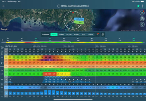
We have used a few weather apps in recent years and have stuck with these. You have to pay for all of them. This morning I compared all the apps with Elsa on approach. There are deviations of 10 kn in the different models. The closer the time, the closer the models converge. So the art is in the accuracy of the longer-term forecast.
PredictWind. We find the weather forecast relatively accurate. Based on this, you can also make a good weather-dependent routing with PredictWind Offshore. The big advantage is that you can choose your weather model, i.e. you have access to different weather models from the USA, Europe or your own PredictWind model. This is our bread and butter application.
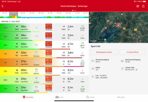
YachtingWeather. Often surprisingly right with wind strengths, at least in the short term for the next day, maximum 2. 3-4 days forecast is very fluctuating and not good for planning. Advantage: you can have a precise position predicted.
WindfinderPro. Last year I found the information consistently too low – and not just a little. I will not be renewing it.
Windy. I have rediscovered this. Here, too, you can choose between different models. Very user-friendly. But still too short in use for an opinion.
WeatherPro. We only use it for local weather, mainly because of the sunshine hours. Not suitable as a wind tool in my opinion.
MeteoEarth. Visually attractive, with wind currents, wind, precipitation. Very nicely done, but only as a supplement. You can hardly see “Elsa” there.
Still to be mentioned:
WindyTy, Weather 4D
Hallo Holger,
gut, dass es solche tollen Vorhersage- und Beobachtung-Tools gibt. Das war vor 50 Jahren sicher noch ganz anders.
Andererseits bleibt es schwierig, sollen Phänomenen wirklich auszuweichen.
In Deutschland nehmen die Hagel- und Starkregen-Phasen sehr stark zu.
In der letzten Woche hat es überall geblitzt und gekracht. Es gibt viele Schäden. Meiner Schwester ist in Bayern der ganze Garten verwüstet worden. So schlimm war es Jahrzehnte lang nicht. Das hängt sicher auch mit der Klimaveränderung zusammen.
Hoffen wir mal, dass es bei Euch keine Ärger von Oben gibt.
Liebe Grüße und alles Gute
Jürgen
Wenn Menschen vom Segeln hören oder lesen, träumen sie sicher gerne von dem “schönen Leben”. Wenn ich jedoch Euren Block mit großem Interesse folge wird mir klar das es auch andere Seiten hat. Es heißt offensichtlich nicht nur gut planen, sondern auch studieren etc. – das macht ihr offensichtlich mehr als gut. Somit drücke ich Euch weiterhin die Daumen -jetzt aus der Dom.-Rep. mit dem Blick auf Elsa, die uns heute morgen nur leicht gestreift hat- für gute Konditionen was Wind und Wetter angeht.
Ihr seid für uns jetzt fasst zum Greifen nah…… bleibt gesund und tapfer
Zum greifen nah = 1169 KM
natürlich Sinnbildlich gemeint.
Liebe Grüße
Jürgen und Angelika