
And then everything turns out differently
While our Rivercafe makes its way north through the waves of the South Atlantic, this is a good opportunity to talk a little bit about the route planning. For days the brave Rivercafe crew has been fighting with 6-7 Beaufort winds, enriched with gusts of 1-2 extra wind forces. On land the garden furniture would be blown away. Therefore the Rivercafe sails strongly reefed. Unfortunately a 3-4 meter wave (and higher) in a 7-10 second rhythm – mostly unpleasantly running crossways – prevents a more brisk ride. No fun at all. I am sure we all agree that “nice sailing” looks different. But the good news: its getting better the closer the Rivercafe gets to St. Helena.
But can you prevent such conditions with good route planning? In our case no, because there are two unchangeable factors: the departure date and the region. At this time of year, these are perfectly normal conditions in the South Atlantic. At the end of the year it gets calmer, but that doesn’t help us at all. However if you are not so strictly bound to dates or routes, a good routing usually helps enormously to sail more relaxed.
The routing on a yacht offshore is a little more demanding than with a car navigation system. When two ships leave the same place and meet again at the same port of arrival, the chance that both sail the same course is as rare as honest politicians. Sometimes it borders on a miracle, but almost everyone arrives – somewhere, sometime. See Columbus. When sailing, route planning is of course also and above all weather planning.
The challenge of routing is to take many and constantly changing factors into account. Nature provides this thrill all by itself. A few constants are determined by man, because the preferred way of sailing of ship and crew, can be very different.
The Yacht
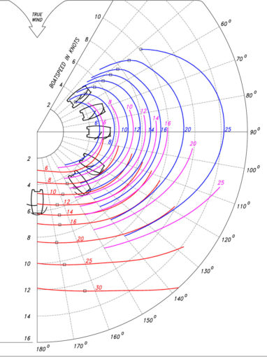
Some routing topics are ship-related, due to construction or equipment. Some ships are good up wind, others are better at reach. Maybe others simply lack the right equipment, e.g. the kite sail for a brisk downwind course. A monohull sails on a different course than a catamaran. Different ship type, different course. But everyone is looking for the “right” course. Ships usually have a polar diagram where you can see the theoretical performance at different wind angles and wind forces. So you know what the ship is capable of and which wind angles – and thus courses – are ideal. A valuable help for every sailing yacht.
The Crew
The motivation of the crew is also extremely important for the choice of course. Regatta sailors get tears of joy when they see a depression and immediately set course for the crisp winds. Cruisers – we count ourselves among them – do exactly the opposite and avoid the deep red, dark spots on the weather chart and choose a different course for relaxed sailing. If you don’t have to catch an airplane on time, it doesn’t matter if you arrive a day earlier or later. The effects of wind and waves on a crew are enormous. Heavy weather can get on your nerves and spoil the fun of travelling. Sleep suffers, restlessness grows and some people are simply afraid. In case of tough prediction we prefer to sail a detour or leave a day later. So everybody has the choice which course is suitable.
Ship and crew are two constants that do not change during the trip. The rest are the variables that make it exciting.
Now the weather
These are the constantly changing factors of weather systems: Wind, gusts – each according to strength and direction, currents, wave height and direction, temperatures and other variables such as geographical conditions, e.g. underwater mountains or isthmus, which have different effects depending on the direction in which they are heading. Of course, there is a weather forecast that uses isobars to report on pressure systems and pulling directions. And there are also sea charts.
The available weather reports are usually great, but only for 3-5 days. If a trip – like the one to the Rivercafe – takes 30-35 days, you can read out your weather forecast of the last 3 weeks just as well from the tea leaves. The weather forecast with this timeline is no help at all for the whole trip planning. It is possible that you have already navigated yourself into a region through which a bad-tempered low will soon rush through, which of course was not to be expected three weeks ago. At least for the rough planning – and that’s not a weather forecast – there are the pilot charts. Jimmy Cornell, for example, publishes such a fat and valuable work. There you can read out at which place of the oceans at which time statistically which winds with strengths and wind directions prevail. Also the usual current is mentioned. Of course this is not a prediction, but for rough planning still better than the tea leaves. So you can at least see which regions you should avoid at certain times.
And back to the weather and the digital age. My Columbus jokes would be much rarer if I had to plan or rather gamble with the means of that time. Sailors do their route planning by computer. There are just too many variables for a small human brain, at least for mine. There are excellent programs or service providers that always recalculate the weather for the respective position, from which a course recommendation can be derived. We use for example “PredictWind“. (But there are many others like Windy or Weather 4D just to mention some others). This is a program in which you configure the individual specifications of your ship – the above mentioned polar diagram -, in our case the Leopard 45. This way, the software recognizes on which courses our Leopard is good and how fast it can sail. Speed is an essential factor. Whether I need 4 hours to get to the next isobar or 14 hours can makes the difference to broken china. So you should not necessarily use the planning tool of an IMOCA 60 racer with 40 kn speed with a cruiser that runs at 10 kn.
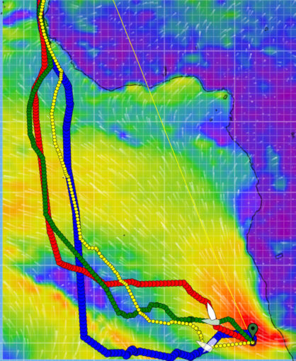
In the planning program, the current position and the target are entered, as well as the resolution, i.e. the measuring points in the KM distance. The region is marked and the appropriate weather report is loaded. For the next 3 days the forecast its usually quite good. The wind is announced in strength and direction, the gusts, the waves, the current and if you like temperatures for water and air, clouds or precipitation. On this basis and taking into account the performance of the ship, the program then calculates a course. Since there are different global weather models based on US and European data, there are several courses to choose from. With PredictWind there are four different. And they can differ greatly, as the Rivercafe planning shows in the chart above. The captain is then spoilt for choice.
All this forecasting costs data volume. For the Rivercafe trip to Tenerife, I can do this from the landline and load the 18.7 MB data volume in a relaxed manner. On a sailing ship offshore this is illusory. To get data on the high seas is damned slow and freaking expensive. 24 KB can take a minute, you can’t even dream of MB downloads. So please do not send cat pictures or baby pictures via satellite mail to any sailor.
Most sailors I know use Iridium satellite phones or Iridium Go. The devices are connected to the computer on board. And then the battle for the amount of data begins. You mark the region on the nautical chart on your computer for which you would like to have current weather data. You send this request via sat com to the weather service, in my case PredictWind, and a few seconds later you get a zipped GRIP file back. You unzip it on your computer, evaluate the new data and decide whether to follow one of the suggested courses. The crux of the matter: of course you would like to have data for a large region, including all kinds of information. But since a maximum of 36 KB is a reasonable amount of data for the satellite transfer, you have to reduce your greed for information more and more until you have weather for a few hundred miles on the screen. And that then certainly without rain, clouds and temperature data and in too large measuring distances.
This is the usual method for normal sailors. The professional shipping industry has other satellite systems, which then cost thousands of euros per month and a completely different hardware on board.
Beside the weather programs there are also weather providers, such as Wetterwelt by Dr. Meeno Schrader. There one receives a special routing by Sat Mail according to previously specified criteria. This is more convenient, but also more expensive than the annual subscription of the weather programs. Great for a unique Atlantic crossing, but in my opinion you need autonomy in the long run.https://www.wetterwelt.de
And once you have received and evaluated your new daily GRIP files once or twice a day, the delighted skipper will do the route planning for the next three to five days. And hopes for the rest that there are still tea leaves left. / Holger Binz
Cost overview:
Costs for route planning p.a: about 1.800 €, which includes
Iridium Go: 770 € (hardware, one-time, extras on top)
Data volume Iridium prepaid 750 € (500/1000 min. sufficient for an Atlantic crossing)
PredictWind 249 USD p. a. (you always need)
In addition, you need a computer or a well-equipped tablet.
Comparison: Weather World Atlantic Package: 549 € – only for the Atlantic Crossing. For the Caribbean you need a weather subscription.
The data volume Iridium we buy only as prepaid. There is an annual subscription for 105 USD per month. But we use our satellite communication only for long crossings. In the Caribbean we use the normal data network of the respective island.